
Canada Topo Maps Pro
by ATLOGIS Geoinformatics GmbH & Co. KG
Version 10,000+ 💾 6 Mb
📅 Updated Eligible if bought after 7/2/2016.
Learn
Topographic Maps 1:50.000 of Canada

Features Canada Topo Maps Pro
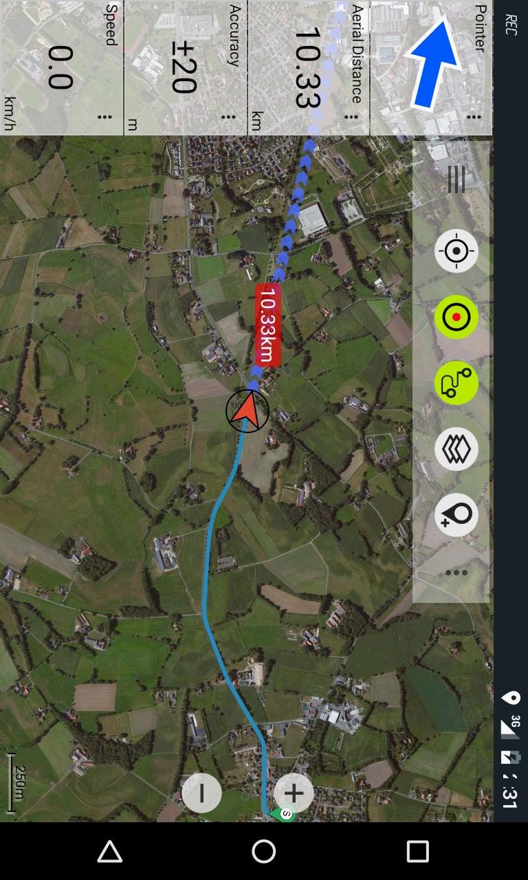
Easy to use outdoor/offline navigation app with the best topographic maps of Canada.This app gives you similar mapping options as you might know from Garmin or Magellan GPS handhelds.*** Attention: Please use Toporama or Canada Base Map layer if you need most recent topo maps !
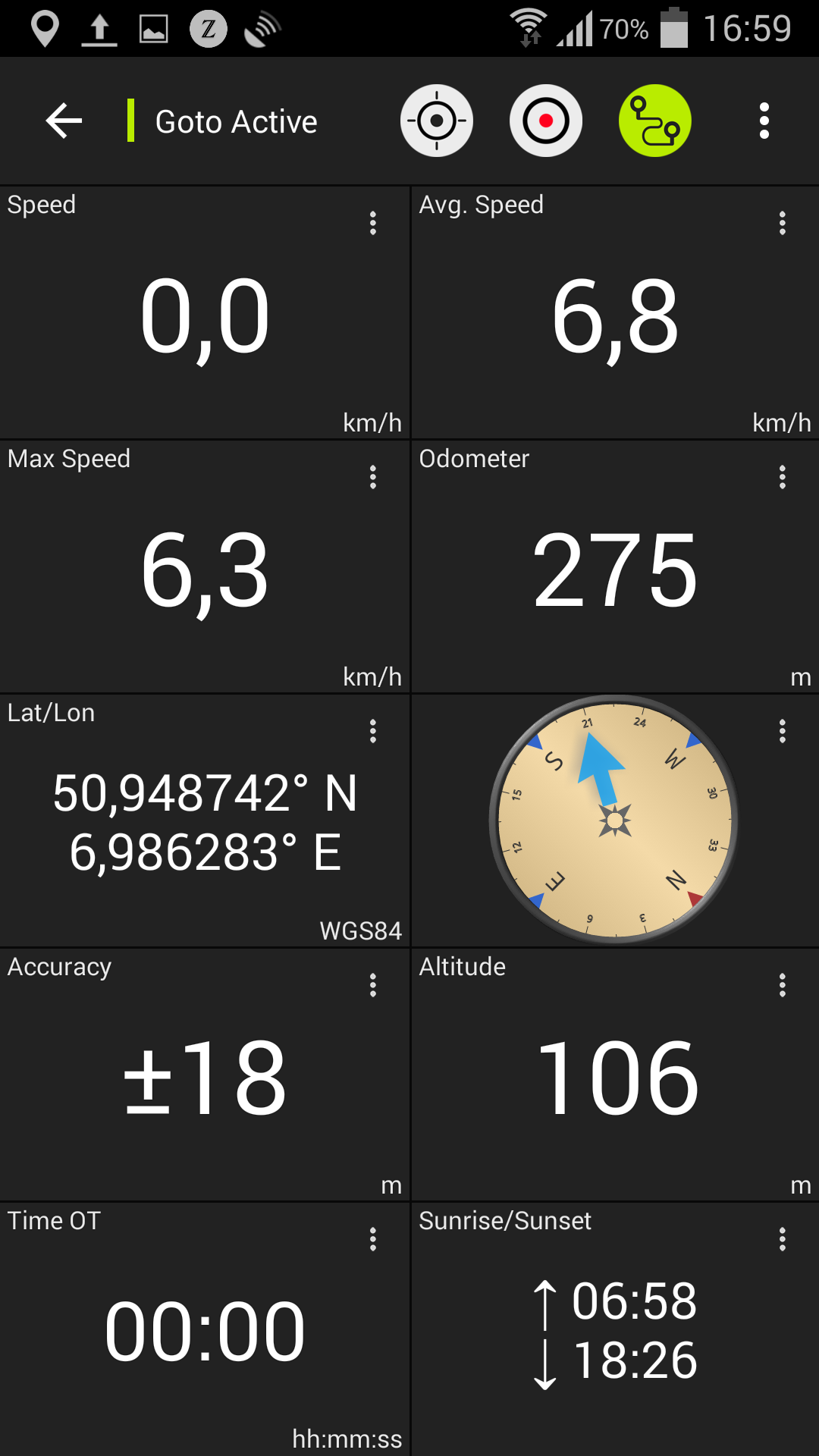
***Main features for outdoor-navigation:• Bulk-download of map tiles for OFFLINE USAGE (not for Google and Bing maps)• Create and edit Waypoints• GoTo-Waypoint-Navigation• Create and edit Routes• Route-Navigation (Point-to-Point Navigation)• Track Recording (with speed, elevation and accuracy profile)• Tripmaster with fields for odometer, average speed, bearing, elevation, etc.
• GPX-Import / Export, KML-Export• Search (placenames, POIs, streets)• Customizable datafields in Map View and Tripmaster (e.g.
Speed, Distance, Compass, ...)• Share Waypoints, Tracks or Routes (via eMail, Facebook, ..)• Use Coordinates in UTM, WGS84 or MGRS• and many more ...Available map layers:• Topomaps Canada (CanMatrix, seamless coverage at scales 1:50.000 and 1:250.000)• Toporama Maps Canada (CanVec, NTDB, Atlas of Canada)• Canada Basemap (CanVec, NTDB, Atlas of Canada)• CanTopo (new Canada topos at 1:50.000, partial coverage of Can)• Google Maps (Satellite images, Road- and Terrain-Map)• Bing Maps (Satellite images, Road-Map)• Open Street Maps (OSM Mapnik and Cloudemade Cyclemap)• Hillshading overlay layer for OSM, Google, Bing or Toporama mapsToporama Maps Canada: These are the most recent topographic maps of Canada.
Can be enhanced with hillshading overlay.Topomaps Canada: These maps contain many small pathes and 4WD tracks that are missing in Toporama, Google, Bing and OSM maps.
This layer is essential for real outdoor and offroad trips in Canada.
Seamless mosaic of more than 13.000 collar clipped 1:50.000 maps.Use this navigation app for outdoor activities like hiking, biking, camping, climbing, riding, skiing, canoeing or offroad 4WD tours.Preload FREE map data for areas without cell service.Canadian topographic maps are enhanced with Atlogis® hillshading and placenames.Credits for topographic map data: "© Department of Natural Resources Canada.
All rights reserved."Please send comments and feature requests to [email protected]• Bottom sheets for markers and waypoints• Improvements & Fixes
Social Features
Connect and share with friends and the community.
Fitness Tracking
Track your workouts and monitor your health metrics.
Travel Features
Plan and manage your travels with ease.
See the Canada Topo Maps Pro in Action
What Our Users Say
Don't just take our word for it. Here's what our users have to say about our Android app.
"Works. Wish the track and follow location buttons were labelled as I often forget which is which. Not as fancy as Gaia but cheaper."
Meghan Anderson
"App works great for what I was looking for for, hiking and exploring off the grid. Combined with QGIS software and a little learning I was able to make custom map layers from various free sources such as (Sentinel 2 satellite with 10m coverage every 5 days) data. Just what I was looking for to upgrade on my handheld unit. One problem with tracking was solved by ensuring app had location fix before hitting the track record button."
Caleb Phillips
"Very good ! Simple and efficient."
Marco Spenard
"A very good tracker for back country skiing and hiking."
A Google user
"Great app caching offline seems to have a bug it downloads incredibly fast for the first 20 seconds then speed drops down real slow very quickly no matter how many times you try. Ended up caching smaller sections"
Andrew Newnes
"Meh"
Mar-Tan Fulford
"Still getting use to it"
Ben
"Amazing app it guide me where to go"
Marvin Atqittuq
"Great map app. Lots of layer/maps available, can store waypoints, make tracks/routes, export data, and lots of different information from gps(speed/bearing/time/altitude etc.)"
Curt Hegel
"This is the only maps I can find of Northern Manitoba. Been using it for years to follow boating tracks on lakes, pin fishing spots, rocks to avoid, etc. Only thing I would like to be added is to have the app auto follow your position instead of having to scroll after yourself while you move. Edited: I will give that a try next time! Thanks Edit: Edit: March 2022! App is perfect! Thanks. Tracks works too. User error on my end"
Jeremy Mccomas
Get the App Today
Available for Android 8.0 and above